

Oct18
Sarnia Artists’ Workshop Awards/ Peg Kivi Solo Exhibition
Sun, Oct 18 · 11:00 am
The Lawrence House Centre for the Arts 127 Christina St. South Sarnia, ON
This panorama from 1912 shows Sarnia shortly before it became a city, looking west toward the St. Clair River.
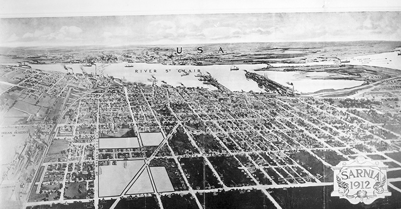
This panorama from 1912 shows Sarnia shortly before it became a city, looking west toward the St. Clair River.
East Street, the town’s eastern boundary, appears at the bottom while Ontario Street, which connected to Plank Road and the oil fields of central Lambton, enters the town at a diagonal angle. The stacks of Imperial Oil can be seen smoking on the river.
Panoramic maps were a popular way to depict Canadian and U.S. communities in the late nineteenth and early twentieth centuries. Also known as bird’s-eye views, they revealed cities from above at an oblique angle. Though not drawn to scale, they did show streets, buildings and major landscape features.
Difficult to see here, this one even depicts streetcars travelling on Russell and Ontario streets.
Photograph courtesy of the Lambton County Archives, Wyoming. Photograph Collection, 9JA-N.
Sun, Oct 18 · 11:00 am
The Lawrence House Centre for the Arts 127 Christina St. South Sarnia, ON
Sun, Oct 18 · 12:00 pm
Lochiel Kiwanis Community Centre 180 College Avenue North Sarnia, ON
Sun, Oct 18 · 2:00 pm
Sarnia Public Library Theatre 124 Christina St. S. Sarnia, ON